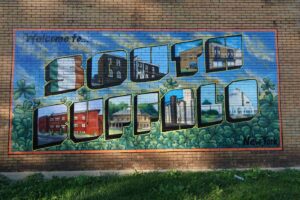
South Buffalo, NY, evolved from 1820s Erie Canal-era Irish immigrant settlements in the Old First Ward into a distinct industrial, blue-collar residential community. Known for its strong Irish, German, and later Polish heritage, the area developed rapidly around Seneca Street, Cazenovia Park, and the South Park area.
Oldest standing house in South Buffalo, 49 Buffum St. Built in 1850.
 With most of the area serving as open pasture lands or relay points during cattle drives, it retained a rural nature until the late 1880s. Amongst the earl y settlers were Charles Hammerschmidt who arrived here from Hesse, Germany, in 1838. Settling in Buffalo, with the assistance of a German architect, he constructed the first private home east of the tollgate. Located at 1849 Seneca, it was also the first house in the city to be insulated. Owning property from the creek to Mineral Springs Road, he raised cattle and poultry on his farm.
Within twenty years, new settlers began to arrive.
- In 1862 the German, John Knoerl, purchased ten acres of land adjoining Hammerschmidt’s and planted a cherry orchard there.
- In April 1866, George Leonard Unger, a cattle farmer from Collins, purchased the property through which Unger Street now runs for use as a stopping point during cattle drives. The property remained in the Unger family until being subdivided in 1910.
- The last large landholder, the German, Louis Zittel, acquired a large expanse of land near Seneca and Cazenovia. A storekeeper by trade, he was instrumental in the establishment of Cazenovia Park, donating a portion of his land for it..
 Developers: To dispel the belief that the Irish were the first to reside in the area, it was actually the Germans who held title to most of the land. William Durstein, a German member of the Buffalo Creek Reservation Land Company, was amongst the first to develop the land for residential use. On land adjacent to the city line, he constructed a large number of homes, creating a tight knit German community surrounding St. Paul’s Reformed Church.
Widespread development of the area was slow in occurring prior to 1900. It was a well noted fact that the area was afflicted by flooding each spring, as both Cazenovia and Buffalo Creeks often went over their banks. Not until the creeks were straightened at the turn of the century did the problem dissipate, clearing the way for widespread development.
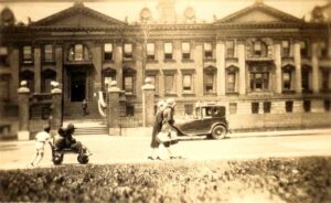
The major person responsible for developing the area was not German but Irish. Known as the builder of South Buffalo, William H. Fitzpatrick resided on a farm at Seneca and Bailey. Working with William J. Summers and Charles Mosher, he built most of the homes in the Butler Park area and many of those on Stephenson, Ryan, Geary and in the Seneca Parkside area. In housing he developed, a large number of Irish families, who moved from the old First Ward after the turn of the century, took up residence. In the 1920s he became a vociferous supporter of the construction of the New York Central terminal on the city’s East Side, campaigning for the passage of the needed legislative approval prior to its construction. (image Cazenovia Street)
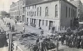
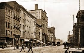 Seneca Street: The final burst of development in the area occurred in the 1920s. In 1926 the International Railway Company began a project to uniformly pave Seneca Street. With work completed, the intersection of Seneca and Cazenovia developed into the commercial center of the neighborhood, enriching the area with much of the character it has today. (image Seneca Street 1900)
Long before homes and farms dotted the landscape of the territory lying between Cazenovia Creek an the shores of Lake Erie, there existed a trail through the countryside there. Constructed by Samuel B Abbott (1792–18780 and Seth Abbott (1770–1845)
In 1809, the road, today known as Abbott Road, served as their link to the city. Moving here from Vermont in 1807, they settled in what was referred to as Abbott’s Corner. It was along this road, and South Park Avenue, the street running parallel to it, that the majority of the area developed.
The first person to settle here, Timothy Hopkins, purchased a large portion of the land in the area, much of which he later sold to other land developers and farmers such as David Bell and George Washington Tifft.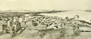
Bell, a Scottish immigrant developed the iron propeller steamer, which played and early role in Great Lakes shipping. Bell Street, in the northwestern corner of the area, originally ran through his farm. At the turn of the century, this area became home to a sizable community of Calabrians from the southern tip if Italy.
George Washington Tifft (1805–1882) was a prominent 19th-century Buffalo capitalist, industrialist, and landowner who significantly shaped the city’s industrial and agricultural development. He owned a massive 600-acre tract in South Buffalo—known as the Tifft Farm—and established a renowned downtown hotel, the Tifft House.Tifft arrived in Western New York in 1826 and purchased a farm in Orleans County. In 1842, he moved to Buffalo and established a partnership with Dean Richmond in the milling Business. Quickly tiring of this, he sold his interest the following year and purchased the Tifft Farm, the area through which Tifft Street runs today. While engaged in numerous other opportunities in Buffalo, including the Tifft House, a Main Street hotel, he operated one of the largest dairy farms in the Buffalo area.
(Tifft House)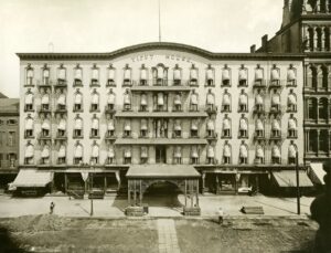
At the southernmost point, on land bordering the current city line, Alexander Aldrich operated a large farm beginning in 1855. Here, he raised celery, black walnuts and flowers. Later, he constructed a greenhouse on South Park and sold flowers to those going to the cemeteries on Limestone Hill. He later sold his farm to the Pixley Land Company for development.
The last farmer of the area, John E. Beale, a Canadian by birth, operated a farm on the east side of Abbott Road. From his home at Abbott and Dundee, his holdings stretched back to Cazenovia Creek. The Kinsey Realty Company later developed his property. Relying on previous experience in the city, the company donated a large tract of land to the Catholic Diocese for the establishment of St. Martin’s RC Church. With the parish clearly established, Irish-Catholic families soon began to settle in its vicinity.
Although the development of the area by land companies resulted in the settlement of the South Park/Abbott Road district, three other factors contributed to it.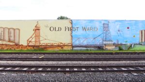
- First, the conditions in the Old First Ward had changed substantially. As business and industry further encroached upon the neighborhood at the turn of the century, more people opted to leave.
- Second, the development of roads and services by the city served to make the area more accessible.
- However, the most influential development in the area occurred in April, 1899, when the Lackawanna Iron and Steel Company announced that it would construct a mill on prime waterfront land nearby. Although located outside the geographic boundaries of the city, the influx of workers to the mill resulted in a high demand for housing in the vicinity. By 1904, almost 7,000 people had relocated to the new neighborhoods in the South Park area to be closer to their place of employment. (image:Lackawanna Steel Company)
1820s–1850s: Origins and Early Settlement
- The First Ward & Canal: Following the 1825 Erie Canal completion, Irish immigrants settled in the “Old First Ward,” working as grain scoopers and in shipping industries.
- Land Use: Initially, much of the area was part of the Seneca Nation’s Buffalo Creek Reservation.
- 1842 Treaty: The Compromise Treaty of 1842 cleared the way for urban development, moving the Seneca Nation south.
- Residential Expansion: Neighborhoods expanded eastward from the First Ward. German immigrants held much of the early land title before the Irish population solidified.
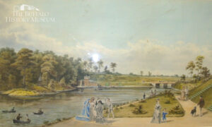
- Olmsted System: The neighborhood became home to a significant portion of the Buffalo Olmsted Park System, (image) including Cazenovia Park and South Park.
- Industry: The area’s proximity to the Buffalo River and Lake Erie spurred growth in heavy industry, specifically steel manufacturing and grain milling, especially after the turn of the century.

- Development of South Buffalo: Developer William H. Fitzpatrick (image) built many homes in the Butler Park and Seneca Parkside areas, drawing residents from the crowded Old First Ward.
- Industrial Hub: The area flourished, supported by its strong connection to nearby steel plants (like Bethlehem Steel) and shipping, creating a tight-knit community.
- 20th Century Infrastructure: By 1926, the paving of Seneca Street cemented the area around Cazenovia Park as a major commercial center.

- Industrial Shift: Similar to the rest of the Rust Belt, the area saw a decline in its industrial base during the late 20th century.
- Cultural Legacy: Despite economic shifts, South Buffalo has maintained a distinct, strong, family-oriented identity and community character.
- 2020s Outlook: The region is currently experiencing a rebirth with new residential construction, renewed manufacturing, and a focus on connecting to the waterfront.
- People: Political figures like Mayor Jimmy Griffin (image) and boxing champion Jimmy Slattery are major figures in the local history.
- Landmarks: ( image below-casino,Cazenovia Park, South Park (including the Botanical Gardens) image above), and countless corner taverns.

Reuben Heacock, (image) a banker and a prominent figure in the fledging city, had been influential in the establishment of the nearby Hydraulics. This glorified mill race (probably the canal that Dearborn spoke of in his diary) utilized water from the Buffalo Creek to power the first manufacturing district in the city. Whether Heacock was a scoundrel or a friend to the Senecas, his association with the Triangle neighborhood is remembered in Heacock Park, 4-acre plot of ground at the juncture of the present Abbott Road, Southside Parkway, and McKinley Parkway.
The Buffalo Harbor from The Terrace, 1825 In its earliest days, two important regional north-south thoroughfares, Abbott’s Corners Plank Road (present Abbott Road) and White’s Corners Plank Road (present South Park Avenue) crossed the Triangle neighborhood. Where they met, an intersection formerly known as Martin’s Corners (and the locale of Heacock Park), was three-and-one- half miles from Niagara Square.
Spring rains invariably brought flooding of the Buffalo and Cazenovia Creeks and the proliferation of rail lines made travel to the area from the north nearly impossible.